Geospatial Analysis for Social Equity and Development
Mapping healthcare accessibility in DRC
In this paper, a processing model was designed to analyze and map the infant population (aged 0–1 year) living more than 30–45 minutes from health facilities. Spatial analysis methods were used to estimate the number of infants requiring vaccination. Read the paper

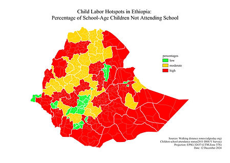
Mapping child labor and school accessibility in Ethiopia
In this paper, a variety of spatial analysis methods were employed to investigate the complex relationship between child labour and the lack of educational infrastructure in Ethiopia. Read the paper
Mapping conflict zones in South Sudan
This paper examines the puzzling political trajectory of South Sudan following its independence in 2011. Despite early optimism, the country rapidly descended into political fragmentation and civil war by 2013. By drawing on empirical evidence, this study tries to understand a counterintuitive question: Why did increased international aid and extensive Disarmament, Demobilization, and Reintegration (DDR) efforts coincide with rising levels of violence in post-independence South Sudan? Read the paper

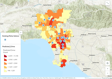
Crime rate analysis and police station optimization in LA
This study is intended for administrative officials and law enforcement agencies in Los Angeles City and aims to answer: Which areas are predicted to have a high risk of crime in the future? How should police stations be optimally located to effectively cover high-risk areas (proposal for new locations based on the location-allocation model)? View the Storymap